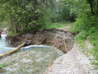
South Fork Sauk River, from the Monte Cristo Town Site Trail, mile (approx) 0.75.
To celebrate the Fourth, we decided to go hiking. On Frank's advice, we went on a hike to the old historic silver mining camp of Monte Cristo. Off the Mountain Loop Highway, a two-lane scenic highway that winds around Granite Falls, Darrington and Arlington (the latter two being near where I hiked last weekend with Elise). We also used our hiking-with-dogs book, which was apparently published before 2006, when we understand some winter storms did a number on the trail.
To celebrate the Fourth, we decided to go hiking. On Frank's advice, we went on a hike to the old historic silver mining camp of Monte Cristo. Off the Mountain Loop Highway, a two-lane scenic highway that winds around Granite Falls, Darrington and Arlington (the latter two being near where I hiked last weekend with Elise). We also used our hiking-with-dogs book, which was apparently published before 2006, when we understand some winter storms did a number on the trail.
Finn sporting his new threads.
Decked out with a day pack (with first aid kit and emergency blanket, our lunch and snacks, extra clothes, and water), and Finn with his brand new dog-pack (with his lunch and snacks), we hit the trail at 12:01pm. We got to the trailhead just fine (the Mountain Loop Highway has also had it's share of trouble over the last few years), but the trail (Monte Cristo Town Site Road/Trail) had issues. It had some mass wasting damage that we couldn't identify, it just looked like a five-foot-deep canyon cut into snow and forest slash (the WTA trail report calls it a clay slide), and then the bridge that the book refered to has been washed out completely by the South Fork of the Sauk River. We talked to a pair of outbound hikers who informed us that the only way to cross the river was via a log crossing.
Eric and Finn, post log-crossing (we took Finn's pack off to let him dry and regain his composure).
Now, incase you weren't aware, our dog Finn -- once he figured out how -- loves to swim. I think he might think twice about swimming in swift, cold current though. He got close, too close, and fell in for a short, heart-stopping moment. Fortunately, his dog-pack has a handle on the back so you can grab the dog as though he were a piece of luggage, which Eric promptly did. We had to hand Finn to each other to get on and off of the fallen log that was passing for a bridge that day, which was a little nerve-wracking for me, who naturally lacks the upper body strength that Eric has (I hike faster to make up for it... where did we put that medicine ball anyway?).... to say nothing of how Finn was feeling about the whole ordeal. But we managed to get to the other side and get our hike back on track. I must say, regarding the river, that it has some of the clearest water I have ever seen in a mountain river. The road continued on the other side, but was laden with issues there too....
Trail washout (or river expansion, depending on your perspective). The trail consists of an old railroad grade, though we marveled at how they apparently buried the old rails instead of pulling them up as is usually the case.
There were many trees down, which Finn lept over without a second thought, and a few that provided me with camera fodder....
The undersides of fir needles, taken from above.
We reached the town site of Monte Cristo, a cluster of five one-room cabins, some mining artifacts and a rail car turntable. The trail continues to Silver Lake via Poodle Dog Pass, but we decided that that would be a hike for another day. We had our lunch of PB&J, sunflower seeds, carrots, pluots and nectarines, and Finn had a half-sized meal of kibble (he usually doesn't get a mid-day meal). We took advantage of the solitude, scenery and the auto-timer on the camera and took some family portraits. Then we headed back.
Family portrait at Monte Cristo.
Dicentra leaves with water droplets.
Gratuitous scenery shots....
Eight miles total, 500-foot elevation gain, out-and-back hike. Not bad for our first of the summer. Next up: Taylor River or Mt Rainier (Sunrise area).


No comments:
Post a Comment